by Gautam Gill | Operator
Fronts are classified depending on what kind of air (warm, cold, neither) is advancing onto the air in its path. Let’s look at the main types of fronts:


by Gautam Gill | Operator
Fronts are classified depending on what kind of air (warm, cold, neither) is advancing onto the air in its path. Let’s look at the main types of fronts:
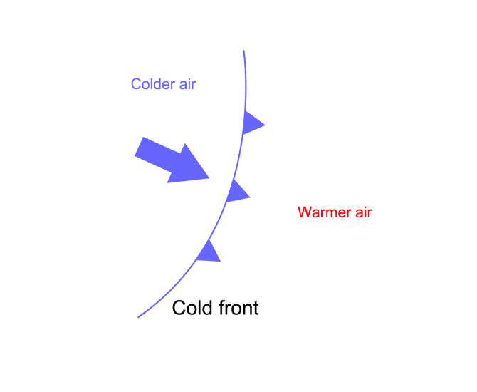
On the weather map, a line with blue triangles represents a Cold Front, pointing in the direction it’s moving. A cold front is just a cold air mass pushing warmer air mass away as it advances.
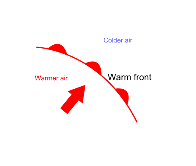
The red line with the circular symbols represents a Warm Front, which is a warm air mass displacing a colder one as it advances.
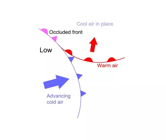
Sometimes, a cold front will “catch up” to a warm front and overtake both it and the cooler air out ahead of it. If this happens, an occluded front is born. Occluded Fronts get their name from the fact that when cold air pushes underneath warm air, it lifts the warm air up from the ground, which makes it hidden, or “occluded.”
Occluded fronts usually form with mature low-pressure areas. They act like both warm and cold fronts.
Cold fronts and Warm fronts bring sudden weather changes. If there’s not a front passing, the weather will likely stay the same as it is now or change very slowly. But if you’re out at sea you need to be able to predict a change in the weather, whether it will get better or worse.
Let’s talk first about a Cold Front since if you’re out at sea, it’s the more dangerous of the two.
The first indication that the weather pattern is changing is the appearance of Cirrus clouds, these are thin wispy veil light clouds. They’re very high up.
We can’t tell immediately what’s about to happen but the appearance of Cirrus clouds means something is coming.
If the Cirrus clouds start to clump together into cirrocumulus clouds. We can now tell that a Cold Front is coming!
These clouds then begin to move downward and form Alto Cumulus clouds. Alto means high and you can see how these clouds form irregular patterns
The Alto Cumulus clouds continued to move downward and form Cumulus clouds, the white puffy ones. And eventually the Cumulus clouds build into Nimbo Cumulus clouds. “Nimbo” means rain and these clouds bring rain if they build big enough. They’re called thunder heads and bring thunder lightning, high winds driving precipitation and hail. This can turn sea conditions from calm to angry and pretty rapidly.
Okay, let’s talk about warm fronts as I said earlier, these are much less violent events than the cold fronts.
Like Cold Fronts, Warm Fronts are preceded by the appearance of cirrus clouds. Next these Cirrus clouds start to form high layered clouds called Cirrostratus clouds. “Stratus” means layers these Cirrostratus clouds move along and are replaced by altostratus clouds which of course is high layered clouds.
Now you should immediately think a Warm Front coming. As the clouds move along those Altostratus, clouds are replaced by regular Stratus clouds that get progressively thicker and thicker and then they turn into Nimbostratus clouds, clouds that deliver rain.
Remember there’s all sorts of severity of Cold and Warm fronts. You can have them so weak they don’t even rain or so strong they can turn into hurricane strength winds!
It’s hard to predict how strong the approaching storm will be but if you keep your eyes on the clouds you’ll at least know the storm is coming and what kind of storm to expect.
So now you know how to predict the weather just by looking at the clouds!
Now I’m going to work out an estimate for the wind direction from a synoptic chart.
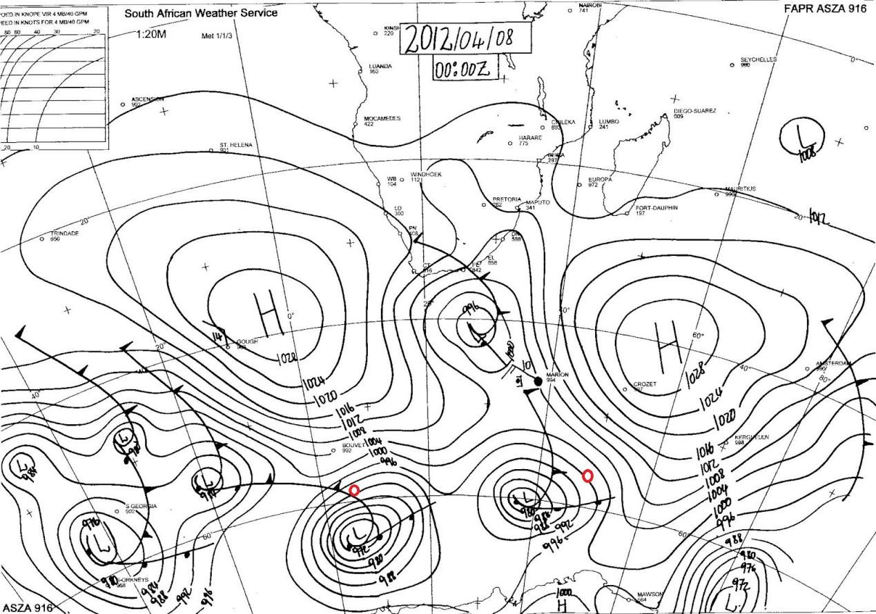
If we look at my position or rather positions (Marked as Red), the first thing I have to do is to draw a line going parallel approximately to the closest isobars so that it crosses Meridian. Because that is how I’m going to work out my direction.
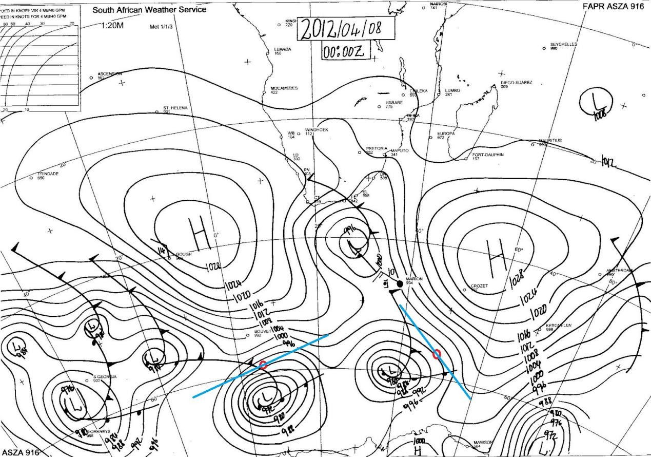
Now using Buys Ballots law, which states that if you’re facing the wind the low will be on your right.
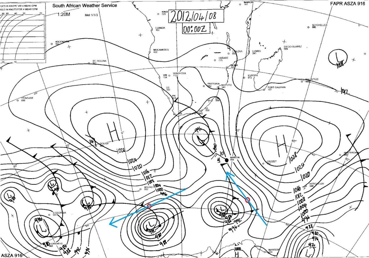
This is the direction of the Geostrophic Wind. At the surface however, we approximate the inflow of Surface wind to be about 15-20 degrees over the sea, so what I’m doing here is, to draw another line approximately 20 degrees going towards the lower isobar swiveling through my point.
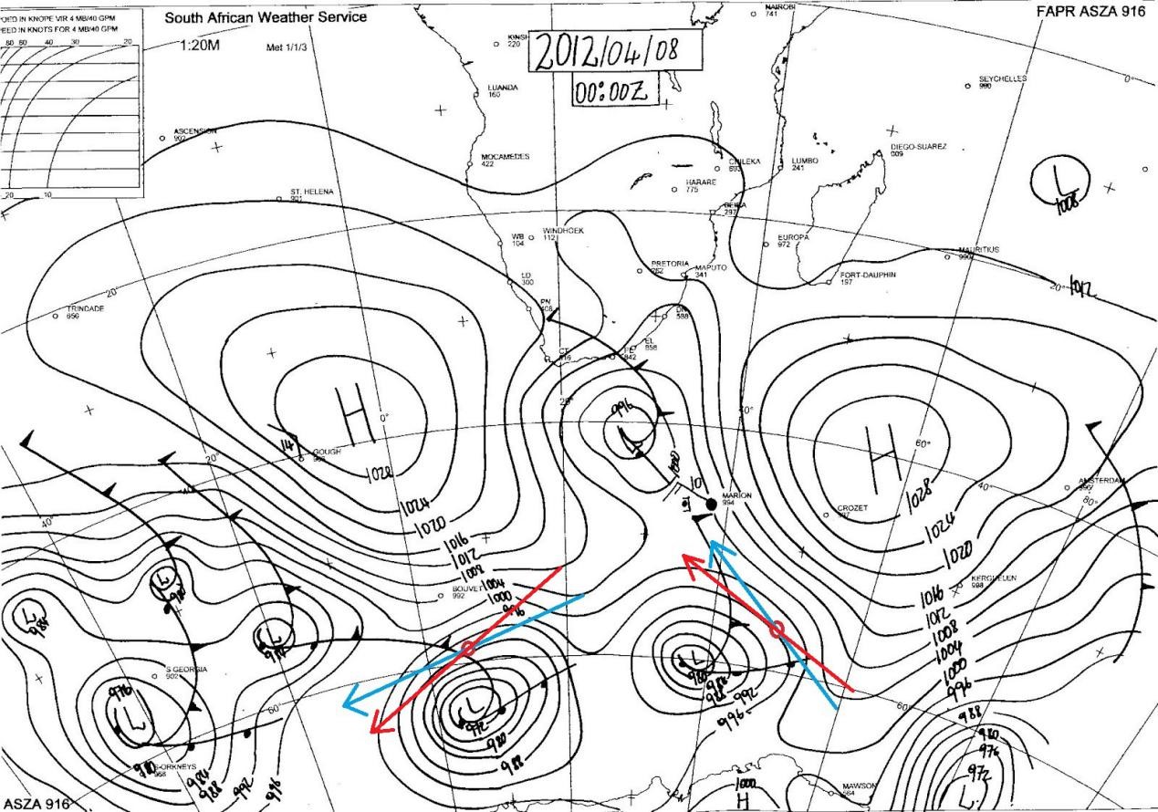
I’m approximating that to be about 45 degrees for the position on the left. The wind is going to be NE’ly 045 degrees! And for the position on the right, estimated wind direction to be SE’ly 135 degrees.
This is again approximate for general direction. A protractor can be used for accuracy.
Understanding the weather chart could be really easy, if we break it down to small parts. Of course, it is an aid to safe navigation.
“Life is like the ocean. Waves will try to knock you down and push you back to where you started. But once you fight through them, the entire ocean is YOURS!” Bon Voyage!!!