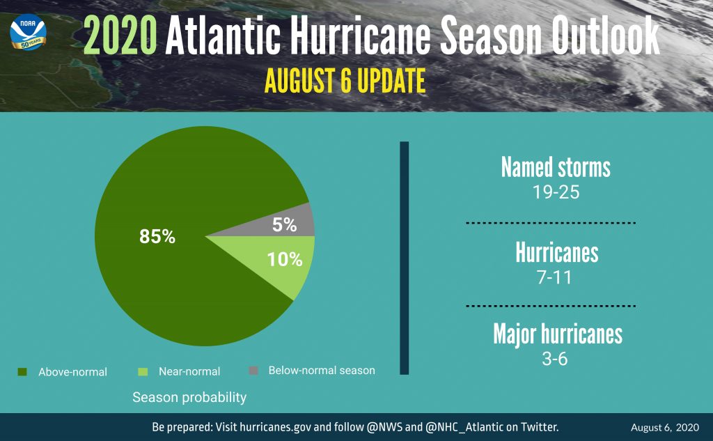
Note: The NOAA and CSU forecasts for total number of named storms, hurricanes, and major hurricanes include the storms which have already been recorded.
As we head into the fall the forecasts from the NOAA and CSU suggest we should see storms of greater severity than earlier in the season. This is to be expected as September is typically the most active month of the hurricane season due to a combination of climate factors. Heat energy stored on the ocean’s surface provides fuel for hurricanes and surface temperature tends to peak in September, increasing the number and severity of storms formed over the Atlantic. Additionally, wind shear, the difference in wind speed and direction over a short distance, is typically lowest in September which also helps facilitate the formation of powerful storm systems.
Why is the 2020 season turning out to be so severe?
The increased severity of this year’s hurricane season is in part due to an La Nina weather phenomenon which both the NOAA and CSU predicted might occur this year and which was confirmed by the NOAA on September 10th. The opposite of an El Nino, a La Nina occurs when the surface temperature of the Eastern Pacific is cooler than usual around the equator. This phenomenon affects weather globally and results in an unseasonably low wind shear allowing more powerful hurricanes to develop in the Atlantic. The La Nina is coming right at the peak of the storm season and can be expected to increase the strength of the hurricanes expected to form between now and the end of the season.
The most severe hurricane season since reliable data has been available occurred in 2005 which also saw a La Nina weather event. During the 2005 season there were 28 named storms, 15 hurricanes and 7 major hurricanes, including hurricane Wilma, one of the most intense hurricanes ever recorded, as well as hurricane Katrina which devastated the city of New Orleans; overall the season caused approximately $180 billion in damages. While the 2020 season is not expected to exceed the severity of 2005, it is on track to become the 2nd most severe hurricane season in terms of the number storms, outpacing the 1995 hurricane season which saw only 19 named storms.
Another driving factor behind this year’s storm activity is rising sea temperatures. The team at CSU cited significantly above-average sea surface temperatures as one of the driving factors behind this year’s season. Some climate scientists are predicting that 2020 could be the hottest year on record, and It is likely that this trend will continue in the coming years and result in more highly active hurricane seasons.
What does all of this mean for shippers?
The updated forecasts and the confirmation that 2020 will be a La Nina year could be bad for shippers operating in the Altantic and Caribbean. Climmate researchers’ predictions tend to be more accurate as the peak of the season approaches and so the latest forecasts are likely to be good predictors of the remaining activity we can expect to see. If the NOAA and CSU forecasts are borne out then over the next few months we can expect more named storms, and likely ones that are considerably stronger than the storms which occurred earlier in the season. In particular, the CSU and NOAA forecasts both suggest we’re in for more major hurricanes this fall as so far we’ve only seen one this season.
Shipowners and charterers need to be extra vigilant over the coming months as the severity of the storms predicted could imperil vessels crossing the Atlantic or in the Gulf of Mexico and Caribbean. It can be onerous for shippers to monitor constantly changing storm conditions and so cautious owners and charterers may consider appointing a qualified weather router for the remainder of the season. TNM monitors storm development 24hrs a day to ensure we can rapidly respond to changing conditions and emergencies, minimizing the risk to vessel crews as well as the client’s bottom line. It remains to be seen how accurate the forecasts for the 2020 hurricane season turn out, however in a year that has already seen record setting storm activity all interested parties should do their best to prepare for the worst.
If you’d like to learn more about TNM’s weather routing services or to request a quote please contact us here.